Airflow, understanding the weather is the key.
Convergence and Divergence
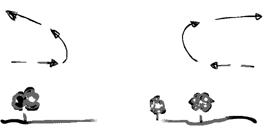
Imagine an exact cube of plasticine or soft clay lying on the floor which we will call earths surface. If you squash the clay inwards from four sides, it will get taller this Convergence an upward motion in the atmosphere.
Now if we take another cube of clay and pull downwards (outwards) in all directions the height of the cube will decrease and this is said to be Divergence a downward motion
DIVERGENCE
Overflow of high pressure into lower layers. (high pressure) Greater in extent than lows, but weaker pressure gradient and slower moving (also good for teaching as the air is sinking and therefore more stable) Winds moves clockwise around the Northern Hemisphere.
CONVERGENCE
Equals rising air that leads to cloud and rain.
DEPRESSIONS
A depression or low pressure is an area of low pressure at the surface. Their is an three dimensional pattern of airflow near a depression.
A: Convergence inflow in lower layers
B: Rising air above.
C: Divergence outflow in upper layers.
The rising air will have an upper limit as it will hit the Tropopause layer which acts like a layer of glass. So low levels of converging air will rush up to meet the layer of glass and spread outwards causing Divergence high above.
This is what happens when a depression is deepening rapidly and the rising air produces a huge region of cloud and rain. The convergence will happen below 500 millibars (18,000ft/5,500 meters) and divergence above this height.
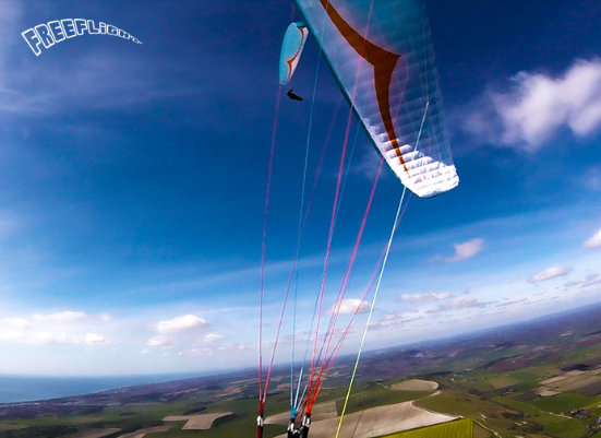
So let us start with how the paraglider produces lift, we will try to keep this simple as possible. If you have a A 4 piece of paper at hand pick it up and hold it by the corners in each hand. (Hold it landscape stile, with the paper drooping)
Now place it to your lower lip and blow over the top of the paper, the paper should rise! Why because you have just produced your first lift by sending the air over the paper faster than it can travel underneath. This is called low pressure and is what makes the lift over the curved paper. We can see this in the diagram below more clearly.
This is a large body of air showing little horizontal variation in temperature or humidity. It is separated from an adjacent body of air by a frontal zone.
If you know the direction of the wind you can start to explain what the air mass will bring and you can forecast the weather ahead.
Tropical airstreams, whether Continental or Maritime will be lighter (less dense) than Polar harasses and will tend to rise over them. And the "front" can be born. A front is the boundary between a Tropical and Polar air mass.
Tropical Maritime
Tropical maritime air approaches Britain from the southwest. Coming from the sub tropical Atlantic ocean, (Azores area) but can come from the Caribbean. The weather to arrive is not warmth sunshine but rather dull, clammy overcast miserable weather. The reason for this is. As it passes across the Atlantic all the way it cools down a little of its moisture is lost. So as it reaches Lands end or western Ireland it is near enough saturated.
Sea fog is common in these Tropical maritime southwest winds. If cloud base was a couple of hundred feet up, then sea level sites will be saved from the fog. But soon as the air mass hits rising ground then hill fog and drizzle will occur.
Places like North Wales Northumberland, Moray Firth and Aberdeen areas can have spring like weather on a January day because of the mountains absorbs some of the moisture leaving a cloud free conditions.
Dew point in a Tropical maritime air mass will be high usually around 15c (59f) in summer and 9c (48f) in the winter and the nights will be mild and damp. In regards to flying this means that in the morning of the next day the temperature is nearly the same, if the air was cold there would be a better chance of thermals. So south west means not much in the way of thermals except in early March and late September when the air tends to be much cooler.
By now you should be thinking of wind directions as conditions, most people think of it will be North west tomorrow there for it will be on at Devils Dyke, Hay Bluff, Coombe Gibbet ect
What you should be thinking of is the wind direction is a Polar Maritime there for the air is cool bit fresh in the summer, even fresher if a cold front should pass the night before. And very thermic, this is not the airflow a beginner should fly in. This is because of the vast temperature difference that will occur during the day. The flying conditions could be an handful to a novice club pilot, but to an experience pilot it could be a good day for a cross country.
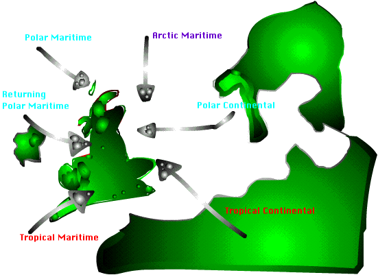
This air comes from the South east, the air flow travels across Spain, France and originally comes from the Sahara.
This is why it is dry and hot in Summer, while flying in the U. K in summer the ground heats up and we have a sea breeze this will had to the wind strength. Now from a flying point of view this air flow is the same temperature, not much difference between the air and ground. So we are left with a steady smooth airflow to teach in.
The wind may well be a light north east (land breeze in the morning) but will come around quickly to a south east by 11am in mid summer. Places like Beachy Head would not be good to fly. This is because the high pressure cannot rise to the top of the cliff, as high pressure is a sinking air flow.
Polar Continental
This air comes from places like Russia, with it we have a cold dry air flow. We would see this airflow more in the winter in the U. K when a high pressure system sits over us.
Now in the summer this air flow is a bitch to teach in as the sun is out and the air flow is very cold. The big temperature difference will cause harsh thermals to travel quickly up the slope. Making the air flow hard work for the student to manage, however if the sky has a layer of cloud the sun will be shut off and the air flow becomes steady and smoother.
In winter this air flow is great to teach in as it is nearly always smooth and steady, even if a bit too cold. See for yourself on
Polar Maritime
This direction has to be my favorite air flow, it arrives from places like Greenland. It has a coolish feel to it, you can feel and smell the thermals as you arrive on the site. They are like sweets to a child, big and chewy, something to get your teeth into.
The air is so clean and Cumulus clouds start to build, you might remember waking up on a Sunday morning around 9am, looking out the window and thinking what a great day. The sky is cloud free and no threat of rain, by 12 the whole sky is covered in cloud. We call them cloud streaks or over developing, you call it something else. For us we can have cloud suck, if you are good you could fly from cloud to cloud and remember there are lots of them.
If you are near the beach the sea breeze will try and push the north west wind back inland up to 15 miles (summer only). This changes the direction from north west to a south west so do not arrive at 1pm and expect the wind to be north west, in fact it could be that you arrive and see everyone at cloud base riding the sea breeze convergence and heading off on a cross country.
Or that the thermals are too strong on take off, what you should do is go and enjoy the days sun and wait for a while as the sea breeze is like a vacuum once it is filled no more can come in, and just maybe the wind from the north west will push back the sea breeze.
You my find that you have the whole site to yourself, with smooth air and large thermals rising at about 200ft per minute, you will notice them from the swallows catching there evening meal. So always look out the front, most people stand facing there gliders ready for a launch but rarely do they look out the front to see what is coming.
Air clean, good visibility and blue sky's.
Winter flying, epic for the novice club pilot, smooth easy ground handling and top landing.
Summer not much good for teaching in unless you are club pilot to pilot as the thermals can be fast like the hand of God picking you up. To give you can example a friend ask me only the other week while flying at the Devils Dyke, did I know what our climb rate was ? no I said. He informed me that we had traveled 1000ft in under 60 seconds from just 150ft above the take off. I remember I said I had looked up just incase there were other pilots above us and my glider was not there. This is because the glider had such a high angle of attack it was sitting right behind me.
I am not trying to put you off the sport, but make you are aware of the dangers involved while assessing the conditions. I found them at my limit but I felt in total control with the conditions as this is what I had expected my flight to be.
Other pilots said it was rough and they could not wait to come down, they had maybe under estimated the conditions or had they just taken off and then thought get me down.
Artic Maritime
Now this airflow can have a bite in it in the summer, the airflow is like its name Artic very cold mixed with the sun the temperature can be very extreme. Thermals could be punchy and slap you across the face, watch out for turbulent air.
In the winter the airflow is steady and ideal to teach in is you can hover like a bird of prey above the take off and practice top landings. Most people do not start flying at this time of the year and most students by this time are on there club pilot tasks. One of them could be soaring and top landing, not many people means your soaring time can be as much as 30 minutes, before I ask you to top landing for a short debrief and then off again for another half hour flight.